inside of Mushpot Cave.jpg', 'nph_window', 'width=400,height=400,toolbar=no,menubar=no,status=yes,scrollbars=yes,resizable=yes'))
)
)
)
)
)
)
)
)
)
)
)
)
)
)
)
)
)
Day 27 - Tuesday 7/26/2005 - Underground pictures...
The plan for the day was to spend the morning exploring Lava Beds National Monument, and then head down to Redding to get the car checked. We broke camp, ate some dry cereal, and prepared to explore. (Editor's note: - dry cereal is a MUST for anyone on a diet. After several days of Apple Jacks scraping the roof of your mouth, you find that you eat only what you must to quell the hunger pangs.) There are hundreds of documented caves at Lava Beds, many of which are open to the public, and probably several times that many that have never been discovered. All of the caves (actually "tubes") were formed from the Medicine Lake shield volcano which formed a huge network of tubes that were all interconnected at one time.
We started out at Mushpot, which is an easy, self-guided tube. Although it's educational, it's not very adventurous. We soon found ourselves scrambling through the Golden Dome Cave, and then the Blue Grotto Cave with our flashlights in hand. It was time for something a little more adventurous.
We had picked up a map of the Catacomb Caverns at the visitor center. The Catacombs is a network of interconnected tubes and caves that weave for a total of more than a mile underground. Near the entrance, we met up with Jill (from PA) and Brett and Kasa (spelling?). We made for a motley crew, and between us we had the gear for ONE spelunker. Jill had the kneepads and jeans, and Hunter and I had the lights. Brett was in shorts, and Kasa was wearing a dress, but all came ready for an adventure. The Catacomb Caverns start out fairly easy, but after a few twists and adjoining tunnels, I was glad to have a map. We used a system of taking the right-most tunnel on the way in and we would follow the left most on the way out. While the map was helpful, one lava tube looks like the next and we struggled trying to find our location on the map. After about 15 minutes of walking, the cave pinched to about 24 inches in height, and we began the first of many belly-crawls across the rough ah-ah lava. After several more crawls, we reached a point where the tube height dropped to about 18 inches. Jill, being the most experienced, went ahead, and Hunter crawled midway between Jill and the group to relay communication. After a few minutes of discussion, we realized that we really weren't outfitted to go much further. With limited pads (and one member of the team in a dress) we decided to backtrack and explore a different part of the cave.
Over the next hour and a half, we crawled, scrambled, climbed, and crab-walked through every area of the cave we could find. We reached a level of familiarity with the cave where we could identify where we were at any point, and even remembered where the "short-cuts" were. The diciest part was a climb up a 10 foot lava flow to reach the higher level. Jill went up first to scout the route while I spotted her. It was fairly easy, so we sent the group up one at a time. I came up last (i.e. the biggest), and searched for footholds in the dark. We spent a total of about 2 1/2 hours in the caverns. If I am able, I will scan the map and put it on this page after we get back from the trip.
After finishing the Catacombs, we snapped some pics, chatted and bid farewell the Brett and Kasa. Jill, Hunter, and I moved on to the next cave - Sentinel Cave. This was a fairly simple walk through long tube with an overland hike back. After the hike, we split off from Jill to go back by the visitor center, get a drink, and go through the Labyrinth.
Hunter and I explored the main passages of the Labyrinth Cave, and then moved over to explore an alternate entrance called Lava Brook. As we were getting ready to start down the entrance, who did we see coming out - Jill. She had also been exploring the same cave, but had come in from a side cave. This gives some idea as to the size of the tunnels. We explored the remainder of the cave crawling through several tight passages. All was well, until I heard "RRIIIIPPPP", and lost the back of my pants which caught on a sharp piece of Ah-ah lava. Modesty is not a virtue that is allowed in caving, so we continued on. After exiting the Labyrinth we all went to Skull Cave. Skull Cave was named for animal bones that were found inside by early explorers. A fascinating aspect of the cave is that there is an "ice room" in the base of the cave that keeps ice year round. The ice is transparent for several feet, but man's intervention into the cave has caused the ice to cloud over the last century.
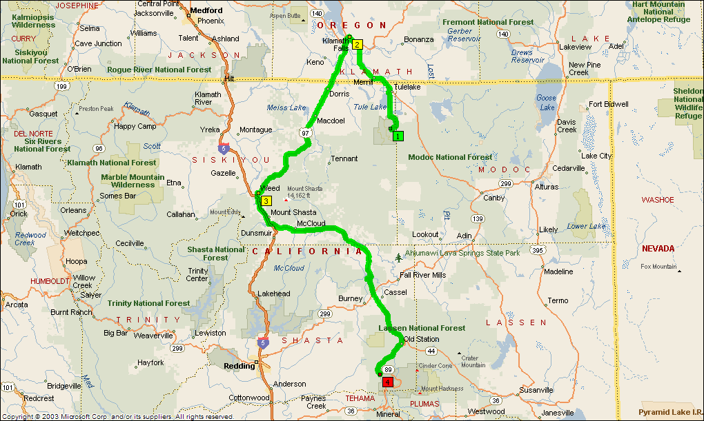
After Skull Cave, it was 6:15 and time to start heading toward Lassen Volcanic National Monument. Jill was heading directly there, and Hunter and I headed north to Klamath Falls to get some radiator coolant. The car was running great as we crept between the caves - no overheating. As we drove, it showed no indication that there was a problem - even as we headed into the mountains. We reached Lassen about 11:30 pm, and the car seemed to be running slightly hot again. After climbing Lassen, we will get it checked in Redding, CA.
|
|
|
|
|
|
|
|
|
|
|
|
|
|
|
|
|
|
|
|
|
|
|
|
|
|
|