Peak Name

Mt. Rogers

Date of Climb

July 5, 2004, June 24, 2005

Published Height

5729 ft

Measured Height

5731 ft  - GPS  

5730 ft  - GPS

Vertical Climb

approx 1500 ft

Published GPS Coordinates

Lat N36º 39' 35"  Long W81º 32' 40"

Measured GPS Coordinates

Lat N36º 39.582'  Long W81º 32.668'

Lat N36º 39.603'  Long W81º 32.697'

Height Rank

19

Difficulty Rank

16


Resources

 Trailmap


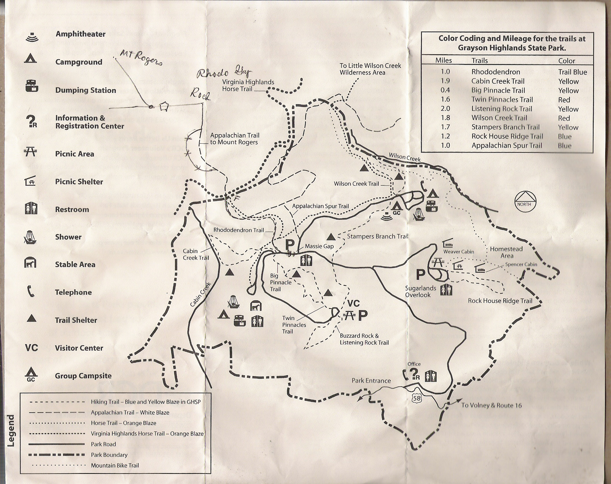
Mt. Rogers is a pleasant hike with gentle hills over a sometimes rocky terrain.  On the day we went, clouds obscured the highpoint, so it was difficult to get a bearing of how far we would be hiking.  Even then, you hike across several other smaller hills until you reach the final climb.  Most of the trail follows the Appalachian Trail and is easy to navigate.  

Mt. Rogers is adjacent to Grayson Highlands State Park, and most of the trail actually lies within the park.  As shown in the pictures below, the trail winds through gentle hills and pastures.  There is even a spot where you encounter wild ponies.

On our visit, we encountered a group of three people where one of them had severely sprained/broken his ankle in a rut.  Although the trail is fairly gentle as far as elevation gain, it is chocked full of rocks and ruts.


The trail from the parking lot.JPG

Team RAZ at the the trailhead.JPG

Clouds roll in as the tril climbs.JPG

Dad takes a rest.JPG

False summit ahead.JPG

The trail from the parking lot

Team RAZ at the trailhead

Clouds roll in as the trail climbs

Dad takes a rest

False summit ahead

Hazy view of the valley.JPG

Hunter makes a friend.JPG

Wheres the food.JPG

Looking at the summit of Mt. Rogers.JPG

Hunter with Mt. Rogers in background.JPG

Hazy view of the valley

Hunter makes a friend

Wheres the food

Looking at the summit of Mt. Rogers

Hunter with Mt. Rogers in background

Lush growth.JPG

Hunter takes a break.JPG

Team RAZ at the summit.JPG

The geo at the summit.JPG

Another geo.JPG

Lush growth

Hunter takes a break

Team RAZ at the summit

The geo at the summit

Another geo

Still another geo.JPG


Still another geo


UPDATE - We revisted and snapped a couple new pics.  The weather was musch better, and this time the camera did not die on us.  We did, however, get a flat tire in the summit parking lot and had to limp to Asheville on a space saver.  Such is the life of a highpointer!!!

On the way to Mt Rogers.jpg

Mt Rogers in the distance.jpg

Dad and Fischer on the trail.jpg

Fischer takes a break.jpg

Hunter and Fischer on the trail.jpg

On the way to Mt Rogers

Mt Rogers in the distance

Dad and Fischer on the trail

Fischer takes a break

Hunter and Fischer on the trail

Team Raz on the Summit.jpg

The Geo on Mt Rogers.jpg

Dad with the highest Bawls in Virginia.jpg

Ponies greeting us on the return.jpg

Hope thats his Mom.jpg

Team Raz on the Summit

The Geo on Mt Rogers

Dad with the highest Bawls in Virginia

Ponies greeting us on the return

Hope thats his Mom

The newset honorary member of Team RAZ.jpg

Getting close.jpg

One more pet.jpg


The newset honorary member of Team RAZ

Getting close

One more pet