|
|
|
|
Peak Name
|
Mt. Davis
|
|
Date of Climb
|
March 14, 2004 |
|
Published Height
|
3213 ft |
|
Measured Height
|
3217 ft (GPS) (3268 ft – top of tower)
|
|
Vertical Climb
|
Short walk from parking area
(one mile from picnic area - elev. 3134) |
|
Published GPS Coordinates
|
Lat N 39°47'10" Lon W 79°10'33" |
|
Measured GPS Coordinates
|
Lat N 39º 47.161' Lon W79º 10.588" |
|
Height Rank
|
33 |
|
Difficulty Rank
|
45 |
|
|
|
|
|

|
|
Resources
|
|
|
|
|
|
|
|
|
|
|
|
|
|
Mt Davis is an easy but pretty peak. You can drive almost to the high
point, with a walk of only a few hundred feet to reach
 your
goal. This was our second attempt to reach the summit. We were
turned away in January when a huge snowstorm dumped 2 feet of snow, and the
temperature on the mountain was 5 below zero with 20-knot winds. By the
second week in March, most of the snow had melted and it was very accessible.
Being unfamiliar with the area, we parked in picnic area on the "back" side of
the mountain and hiked the mile to the summit (worth the walk!). I must commend
the PA DOT - they did a great job clearing access to the summit very
quickly after the storm. The pictures at the bottom of the page are from
the storm trip AND the successful trip in March 2004.
your
goal. This was our second attempt to reach the summit. We were
turned away in January when a huge snowstorm dumped 2 feet of snow, and the
temperature on the mountain was 5 below zero with 20-knot winds. By the
second week in March, most of the snow had melted and it was very accessible.
Being unfamiliar with the area, we parked in picnic area on the "back" side of
the mountain and hiked the mile to the summit (worth the walk!). I must commend
the PA DOT - they did a great job clearing access to the summit very
quickly after the storm. The pictures at the bottom of the page are from
the storm trip AND the successful trip in March 2004.
Directions from the South (DC Area): Follow I-270 Northwest
through Frederick MD. Pick up I-70 west from Frederick and follow it to
the junction of I-68. Follow I-68 west through Cumberland and Frostburg.
Take Exit 22 north (US 219). Go north on US 219 into PA and into the town
of Salisbury. Turn Left onto 669, and follow it until you reach an
intersection. Turn RIGHT onto St. Paul Road. (Most folks turn left,
but I think this is a faster way - confirmed by a local.) The road will
make a sharp turn to the left about 1200 feet - this is still St. Paul Road.
Stay on this road until you reach the town of St. Paul's, where you will make a
left turn (again you will still be on St. Paul's Road). This road is also
SR 2003, and it will soon turn into Mt. Davis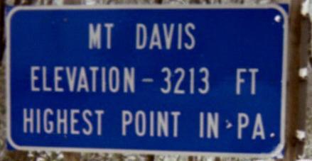 Road. Stay on Mt. Davis Road for several miles, and when you see a radio
tower, you are almost at the top. Across from the radio tower is a picnic
area with a 1 mile trail to the summit. After passing the picnic area you
will see a blue highway sign proclaiming you have reached the summit of Mt.
Davis (close, but not really!) Shortly after that there will be a road to
your left (South Wolf Rock Road). Follow this road to a parking area that
is a stone's throw from the tower.
Road. Stay on Mt. Davis Road for several miles, and when you see a radio
tower, you are almost at the top. Across from the radio tower is a picnic
area with a 1 mile trail to the summit. After passing the picnic area you
will see a blue highway sign proclaiming you have reached the summit of Mt.
Davis (close, but not really!) Shortly after that there will be a road to
your left (South Wolf Rock Road). Follow this road to a parking area that
is a stone's throw from the tower.
Synopsis: An easy peak in good weather (bring the snow gear
in the middle of winter). Nice areas to picnic and hike, and a good view
from the tower. It was a little hazy on our visit, so I plan to go back in
spring or summer. If you look to the south-southwest, you can see the
windfarm (huge windmills) on Backbone Mountain (the highpoint of Maryland).
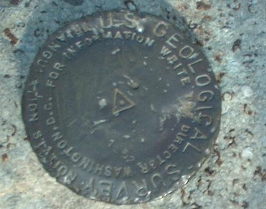
Mt Davis is one of the few highpoints I have seen with good info on plaques
showing the history and geology of the mountain.
Additional Pictures:
Winter trip:
Spring (successful trip)
Updated 3/29/2004
)
)
)
)
)
)
)
)
)
)
)